
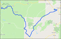
This 45 mile ride begins in the small hamlet of Bixby MO on State Hwy 32.
Once you turn south onto SH 49 you will find a great canopied winding road
that will thrill your senses.
Bixby to Elephant Rocks - 45 miles
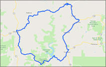
This 70 mile ride loops Clearwater Lake located in the area of the valley where
Iron & Reynolds county meet. Know for the grandeur of it's hills, natural
springs, and splendid beauty.
Clearwater Lake Loop - 70 miles
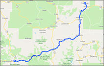
Enjoy the back roads of this ride that twist through the Mark Twain National
forest. The beginning of this ride SH A is wildly twisty, and a thrill to ride.
Current River to Lesterville - 49 miles
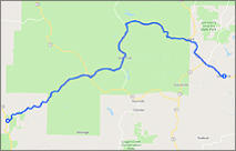
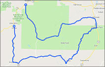
This 71 mile ride offers some great sweeping and scenic vistas to thrill the
senses. If you're heading to the valley from the southwest for the weekend
then this a great route.
Eminence to Pilot Knob - 71 miles
This 72 mile is in our estimation one of the best in the Ozarks. If you enjoy
canopied "Dragon" like roads, then this ride is your promise land.
Mill Creek - Saco Loop - 72 miles
SHARE WITH US
Copyright © 2026 - Ozark Rides, All Rights Reserved


Arcadia Valley - The Jewel of the Ozarks
As a serious rider you're always seeking to find "The Perfect Road", you know the one you can't wait to get back to. When I was invited to visit Arcadia
Valley Missouri I must admit that the vision that I had in my head was that of just another typical sleepy Missouri back road community... Boy was I ever
wrong.
Seldom does a rider find Valhalla in their own back yard, but the 900 square mile region known as Arcadia Valley is just that. The communities of Pilot
Knob, Ironton and Arcadia are nestled in the picturesque valley of the St. Francois Mountains and besides the over the top scenic rides, there are so many
things to do while visiting the area.
Known for its red brick Iron County courthouse, graceful antebellum homes
and turn-of-the-20th-century mercantile buildings, Arcadia Valley was a
popular 19th century summer resort. During the Civil War, the valley was
the site of a significant battle at Fort Davidson in Pilot Knob. There are four
major state parks in the valley - Elephant Rocks, Johnson's Shut-Ins,
Fort Davidson Historic Site and Taum Sauk Mountain (Missouri's highest
peak).
As for the area roads? First let me just say that I have traveled all over the
country on my bike seeking out the best rides America has to offer, from the
Tail of the Dragon to the Beartooth Pass and most points in-between.
All have their own unique features that make them great rides, and like
anything else, finding the best ride is certainly subjective. For me the best
ride bar none is the Beartooth Pass in Wyoming. That being said, I think
you'll find the back roads of this valley can hold their own against the best
of them. They are absolutely as good as, and to some maybe better (again subjective) than any in the Ozarks. From winding and canopied “dragon like”
roads to scenic vistas, you're definitely going be thrilled with the area and I’m sure you’ll mark it down as a place you’ll want to visit again and again.
Below are eight new rides that I think you’ll love. Of course there will be more ride maps added as I have to opportunity to return to the valley and explore
the beauty that Arcadia Valley has to offer.
“The Arcadia Valley is one of the most delightful places I have ever been, with beautiful scenery all about.”
Ulysses S. Grant - President/General
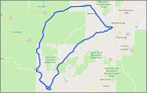
This 50 mile ride loops around and through the Johnson’s Shut-Ins State Park.
Johnson’s Shut-Ins Loop - 50 miles
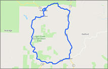
This 43 mile ride begins and ends in Reynolds MO, and loops the Logan Creek
Conservation Area which lies south of Black River and north of Current River.
Logan Creek Loop - 43 miles
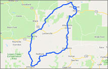
This 85 mile ride loops Taum Sauk Mountain (highest point in Missouri). When
you take this route you might try a short detour on CR CC and ride up to the
Taum Sauk Mtn. peak. (To reach the summit there is a short ride on a good
quality but dirt road).
Ironton - Ellington Loop - 85 miles


Copyright © 2026 - Ozark Rides, All Rights Reserved


Arcadia Valley
The Jewel of the Ozarks
As a serious rider you're always seeking to find "The Perfect
Road", you know the one you can't wait to get back to.
When I was invited to visit Arcadia Valley Missouri I must admit
that the vision that I had in my head was that of just another
typical sleepy Missouri back road community... Boy was I ever
wrong.
Seldom does a rider find Valhalla in their own back yard, but the
900 square mile region known as Arcadia Valley is just that.
The communities of Pilot Knob, Ironton and Arcadia are nestled
in the picturesque valley of the St. Francois Mountains and
besides the over the top scenic rides, there are so many things
to do while visiting the area.
Known for its red brick Iron County courthouse, graceful
antebellum homes and turn-of-the-20th-century mercantile
buildings, Arcadia Valley was a popular 19th century summer
resort. During the Civil War, the valley was the site of a
significant battle at Fort Davidson in Pilot Knob. There are four
major state parks in the valley - Elephant Rocks,
Johnson's Shut-Ins, Fort Davidson Historic Site and
Taum Sauk Mountain (Missouri's highest peak).
As for the area roads? First let me just say that I have traveled
all over the country on my bike seeking out the best rides
America has to offer, from the Tail of the Dragon to the Beartooth
Pass and most points in-between. All have their own unique
features that make them great rides, and like anything else,
finding the best ride is certainly subjective. For me the best ride
bar none is the Beartooth Pass in Wyoming. That being said, I
think you'll find the back roads of this valley can hold their own
against the best of them. They are absolutely as good as, and to
some maybe better (again subjective) than any in the Ozarks.
From winding and canopied “dragon like” roads to scenic vistas,
you're definitely going be thrilled with the area and I’m sure
you’ll mark it down as a place you’ll want to visit again and again.
Below are eight new rides that I think you’ll love. Of course there
will be more ride maps added as I have to opportunity to return
to the valley and explore the beauty that Arcadia Valley has to
offer.
“The Arcadia Valley is one of the most delightful places I
have ever been, with beautiful scenery all about.”
Ulysses S. Grant - President/General
This 45 mile ride begins in the
small hamlet of Bixby MO on
State Hwy 32. Once you turn
south onto SH 49 you will find
a great canopied winding road
that will thrill your senses.
Bixby to Elephant Rocks
45 miles
This 70 mile ride loops
Clearwater Lake located in the
area of the valley where Iron
& Reynolds county meet.
Know for the grandeur of it's
hills, natural springs, and
splendid beauty.
Clearwater Lake Loop
70 miles
Enjoy the back roads of this
ride that twist through the
Mark Twain National forest.
The beginning of this ride
SH-A is wildly twisty, and a
thrill to ride.
Current River to Lesterville
49 miles
This 71 mile ride offers some
great sweeping and scenic
vistas to thrill the senses. If
you're heading to the valley
from the southwest for the
weekend then this a great
route.
Eminence to Pilot Knob
71 miles
This 72 mile is in our
estimation one of the best in
the Ozarks. If you enjoy
canopied "Dragon" like roads,
then this ride is your promise
land.
Mill Creek - Saco Loop
72 miles
Johnson’s Shut-Ins Loop
50 miles
This 43 mile ride begins and
ends in Reynolds MO, and
loops the Logan Creek
Conservation Area which lies
south of Black River and north
of Current River.
Logan Creek Loop
43 miles
This 85 mile ride loops Taum
Sauk Mountain (highest point
in Missouri). When you take
this route you might try a
short detour on CR CC and
ride up to the Taum Sauk Mtn.
peak. (To reach the summit
there is a short ride on a good
quality but dirt road).
Ironton - Ellington Loop
85 miles


MENU