
SHARE WITH US
Copyright © 2026 - Ozark Rides, All Rights Reserved


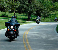
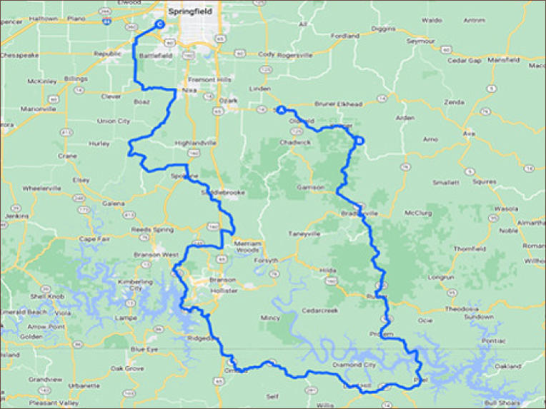
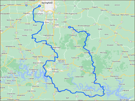
This 183 mile ride takes in some of the best roads in Southwest Missouri. Beginning in Sparta (be sure to
fuel up here), this ride takes you on the Oldfield loop (arguably the best road in S.W. Missouri), then south
on Hwy 125 to the Peel ferry. As you then head north back into Missouri, you get to experience some great
“less traveled” back roads, and Wilson’s Creek National Battlefield. Culminating your ride at Renegade Harley
Davidson.


Renegade Run - 183 miles


Copyright © 2026 - Ozark Rides, All Rights Reserved


This 183 mile ride takes in some of the best roads in Southwest
Missouri. Beginning in Sparta (be sure to fuel up here), this
ride takes you on the Oldfield loop (arguably the best road in
S.W. Missouri), then south on Hwy 125 to the Peel ferry. As you
then head north back into Missouri, you get to experience some
great “less traveled” back roads, and Wilson’s Creek National
Battlefield. Culminating your ride at Renegade Harley Davidson.
Renegade Run - 183 miles
Step by Step Directions:
From Sparta
MO-125, Sparta, MO 13.6 mi, Head east on MO-125 S/State
Hwy 14 E/Main St toward Maple St 0.716 mi Keep right to
continue on MO-125 S/State Hwy 125 S 2.73 mi Turn left onto
State Hwy T 10.1 mi. Turn right onto S State Hwy Uu 338 ft.
State Hwy Uu, Head southwest on S State Hwy Uu toward
Guffy Rd 10.3 mi, Turn left onto MO-125 S 4.72 mi Turn left
onto MO-125 S/State Hwy 76 E 0.663 mi, Turn right onto
MO-125 S 15.3 mi. Turn left onto US-160 E 1.96 mi Continue
straight onto MO-125 S 9.91 mi Continue onto AR-125 S 0.839
mi Take the Peel Ferry. Continue straight onto AR-125 S 7.27
mi Turn right onto State Hwy 268 5.61 mi, Turn right onto
AR-14 N W 21.8 mi, Turn right onto AR-14 N W/Main St
Continue to follow AR-14 N W 3.66 mi. Turn right onto US-65
N Entering Missouri.
Turn left onto State Hwy 265 N 0.749 mi Turn right to stay on
State Hwy 265 N 2.47 mi. Turn left onto State Hwy 265
N/Historic Hwy 165 N Continue to follow State Hwy 265 N
9.65 mi, Turn right onto State Hwy 76 E 0.641 mi, Turn left
onto the MO-465 N/US-65 N ramp 0.300 mi, Continue onto
State Hwy 76 7.25 mi Turn left to merge onto US-65 N toward
Springfield 2.34 mi. Take the US-160 ramp to Reeds Spring
Jct/Forsyth 1,276 ft. Turn right onto US-160 E (signs for
Forsyth/Lake Taneycomo/Bull Shoals Lk) 1.67 mi, Turn left
onto MO-176 W 4.74 mi Turn right onto US-65 N 0.919 mi.
Turn left onto MO-176 W 7.48 mi, Turn right onto US-160 W
2.05 mi, Turn left onto State Hwy V 6.02 mi. Slight right
toward McCall Bridge Rd 584 ft, Merge onto McCall Bridge Rd
2.05 mi. Turn left onto Aa-100/Warner Rd 2.06 mi Turn right
onto State Hwy AA 2.17 mi, Turn right onto State Hwy A 0.842
mi Turn left onto State Hwy U 3.13 mi, Continue onto State
Hwy M 6.98 mi Turn left onto State Hwy 14 W 4.31 mi Turn
right onto Holder Rd 2.11 mi. Turn right onto State Hwy ZZ
5.16 mi, Turn right onto W Republic Rd/W Rudolph Rd/W State
Hwy M/W State Rte M 1,237 ft , At the traffic circle, take the
3rd exit onto S Farm Rd 103 0.963 mi, Turn right onto MO-413
N/US-60 E Continue to follow MO-413 N Destination will be on
the right 3.56 mi. Renegade Harley Davidson.


MENU